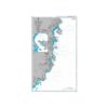

British Admiralty Nautical Chart 3888 Outer Approaches to Hon Gai
₱3,000.00
British Admiralty Nautical Chart 3888 Outer Approaches to Hon Gai
is corrected up to date. Admiralty standard nautical charts comply with Safety of Life at Sea (SOLAS) regulations and are ideal for professional, commercial and recreational use. Charts within the series consist of a range of scales, useful for passage planning, ocean crossings, coastal navigation and entering port. Mariners should always use the largest scale nautical chart appropriate to their needs. In particularly busy seaways such as the English Channel, Gulf of Suez and the Malacca and Singapore Straits, the standard nautical charts are supplemented by mariners routeing guides which provide advice on route planning in these complex areas.
Chart 3888
Main Chart Details
- Chart Title: Outer Approaches to Hon Gai
- Publication Date: 26/12/2013
- Latest Edition date: 26/12/2013
- Chart Size: 638 x 974 (mm)
Chart Panel Details
- Panel Name Outer Approaches to Hon Gai
- Area Name Vietnam – North East Coast
- Natural Scale 25000
- North Limit 20 49′.30N
- East Limit 107 15′.20E
- South Limit 20 36′.10N
- West Limit 107 06′.00E
Be the first to review “British Admiralty Nautical Chart 3888 Outer Approaches to Hon Gai”
Related products

British Admiralty Charts
British Admiralty Nautical Chart 38: Karachi to Ra’s al Hadd
British Admiralty Charts
British Admiralty Nautical Chart 18: Falmouth Inner Harbour Including Penryn
British Admiralty Charts
British Admiralty Nautical Chart 7: Gulf of Aden, Yemen, Aden Harbour and Approaches
British Admiralty Charts
British Admiralty Nautical Chart 30: Plymouth Sound and Approaches

British Admiralty Charts
British Admiralty Nautical Chart 31: Harbours on the South Coast of Cornwall
British Admiralty Charts
British Admiralty Nautical Chart 17: Plans of the Santa Cruz and Adjacent Islands

British Admiralty Charts
British Admiralty Nautical Chart 5: `Abd Al Kuri to Suqutra (Socotra)
Reviews
There are no reviews yet.