
British Admiralty Nautical Chart 3593 South Sandwich Islands
₱3,500.00
BA3593
Description
British Admiralty Nautical Chart 3593 South Sandwich Islands
is corrected up to date. Admiralty standard nautical charts comply with Safety of Life at Sea (SOLAS) regulations and are ideal for professional, commercial and recreational use. Charts within the series consist of a range of scales, useful for passage planning, ocean crossings, coastal navigation and entering port. Mariners should always use the largest scale nautical chart appropriate to their needs. In particularly busy seaways such as the English Channel, Gulf of Suez and the Malacca and Singapore Straits, the standard nautical charts are supplemented by mariners routeing guides which provide advice on route planning in these complex areas.
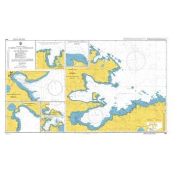
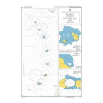
Chart 3593
Main Chart Details
- Chart Title: South Sandwich Islands
- Publication Date: 22/09/1989
- Latest Edition date: 11/09/2003
- Chart Size: 660 x 984 (mm)
Chart Panel Details
- Panel Name Approaches to the South Sandwich Islands
- Natural Scale 500000
- North Limit 55 35′.00S
- East Limit 25 25′.00W
- South Limit 60 00′.00S
- West Limit 28 50′.00W
- Panel Name Nelson Channel
- Area Name Candlemas Islands
- Natural Scale 50000
- North Limit 57 02′.00S
- East Limit 26 40′.00W
- South Limit 57 10′.00S
- West Limit 26 52′.00W
- Panel Name Cordelia Bay
- Area Name Saunders Island
- Natural Scale 50000
- North Limit 57 44′.00S
- East Limit 26 17′.78W
- South Limit 57 49′.00S
- West Limit 26 30′.00W
- Panel Name Douglas Strait
- Area Name Southern Thule
- Natural Scale 50000
- North Limit 59 22′.00S
- East Limit 27 11′.00W
- South Limit 59 30′.00S
- West Limit 27 23′.82W


Reviews
There are no reviews yet.