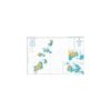
British Admiralty Nautical Chart 793 The Grenadines – Northern Part
₱3,000.00
British Admiralty Nautical Chart 793 The Grenadines – Northern Part
is corrected up to date. Admiralty standard nautical charts comply with Safety of Life at Sea (SOLAS) regulations and are ideal for professional, commercial and recreational use. Charts within the series consist of a range of scales, useful for passage planning, ocean crossings, coastal navigation and entering port. Mariners should always use the largest scale nautical chart appropriate to their needs. In particularly busy seaways such as the English Channel, Gulf of Suez and the Malacca and Singapore Straits, the standard nautical charts are supplemented by mariners routeing guides which provide advice on route planning in these complex areas.
Chart 793
Main Chart Details
- Chart Title:The Grenadines, Northern Part
- Publication Date:27/09/1991
- Latest Edition date: 26/09/2019
- Chart Size:1024 x 651 (mm)
Chart Panel Details
- Panel Name Bequia to Canouan
- Area Name West Indies
- Natural Scale 60000
- North Limit 13 01′.00N
- East Limit 61 05′.00W
- South Limit 12 40′.00N
- West Limit 61 30′.00W
- Panel Name A Mustique
- Area Name West Indies
- Natural Scale 25000
- North Limit 12 55′.70N
- East Limit 61 09′.30W
- South Limit 12 49′.60N
- West Limit 61 12′.79W
- Panel Name B Charlestown Bay
- Area Name West Indies, Canouan
- Natural Scale 12500
- North Limit 12 43′.62N
- East Limit 61 19′.45W
- South Limit 12 41′.22N
- West Limit 61 21′.60W
Be the first to review “British Admiralty Nautical Chart 793 The Grenadines – Northern Part”
Related products

British Admiralty Charts
British Admiralty Nautical Chart 18: Falmouth Inner Harbour Including Penryn

British Admiralty Charts
British Admiralty Nautical Chart 12: Al `Aqabah to Duba and Ports on the Coast of Saudi Arabia

British Admiralty Charts
British Admiralty Nautical Chart 29: Brazil – South Coast, Porto de Santos
British Admiralty Charts
British Admiralty Nautical Chart 34: England – West Coast, Isles of Scilly
Reviews
There are no reviews yet.