
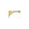

British Admiralty Nautical Chart 657 Ponta da Cafumbila to Matadi
₱3,000.00
British Admiralty Nautical Chart 657 Ponta da Cafumbila to Matadi
is corrected up to date. Admiralty standard nautical charts comply with Safety of Life at Sea (SOLAS) regulations and are ideal for professional, commercial and recreational use. Charts within the series consist of a range of scales, useful for passage planning, ocean crossings, coastal navigation and entering port. Mariners should always use the largest scale nautical chart appropriate to their needs. In particularly busy seaways such as the English Channel, Gulf of Suez and the Malacca and Singapore Straits, the standard nautical charts are supplemented by mariners routeing guides which provide advice on route planning in these complex areas.
Chart 657
Chart INT. 2512
Main Chart Details
- Chart Title: Ponta da Cafumbila to Matadi
- Publication Date: 31/07/2003
- Latest Edition date: 16/02/2017
- Chart Size: 1100 x 753 (mm)
Chart Panel Details
- Panel Name Ponta da Cafumbila to Matadi
- Area Name Angola and Congo (Democratic Rep.) – River Congo
- Natural Scale 50000
- North Limit 5 49′.76S
- East Limit 13 01′.05E
- South Limit 6 05′.00S
- West Limit 12 31′.25E
- Panel Name A Continuation to Matadi
- Area Name Angola and Congo (Democratic Rep.) – River Congo
- Natural Scale 50000
- North Limit 5 47′.79S
- East Limit 13 28′.55E
- South Limit 5 55′.67S
- West Limit 12 58′.75E
- Panel Name B Boma
- Area Name Angola and Congo (Democratic Rep.) – River Congo
- Natural Scale 12500
- North Limit 5 51′.10S
- East Limit 13 03′.70E
- South Limit 5 52′.35S
- West Limit 13 02′.67E
- Panel Name C Matadi
- Area Name Angola and Congo (Democratic Rep.) – River Congo
- Natural Scale 12500
- North Limit 5 48′.48S
- East Limit 13 28′.36E
- South Limit 5 49′.73S
- West Limit 13 26′.66E
Be the first to review “British Admiralty Nautical Chart 657 Ponta da Cafumbila to Matadi”
Related products

British Admiralty Charts
British Admiralty Nautical Chart 17: Plans of the Santa Cruz and Adjacent Islands


British Admiralty Charts
British Admiralty Nautical Chart 5: `Abd Al Kuri to Suqutra (Socotra)

British Admiralty Charts
British Admiralty Nautical Chart 29: Brazil – South Coast, Porto de Santos
British Admiralty Charts
British Admiralty Nautical Chart 9: La Skhirra, Gabes and Ghannouch with Approaches
British Admiralty Charts
British Admiralty Nautical Chart 34: England – West Coast, Isles of Scilly
Reviews
There are no reviews yet.