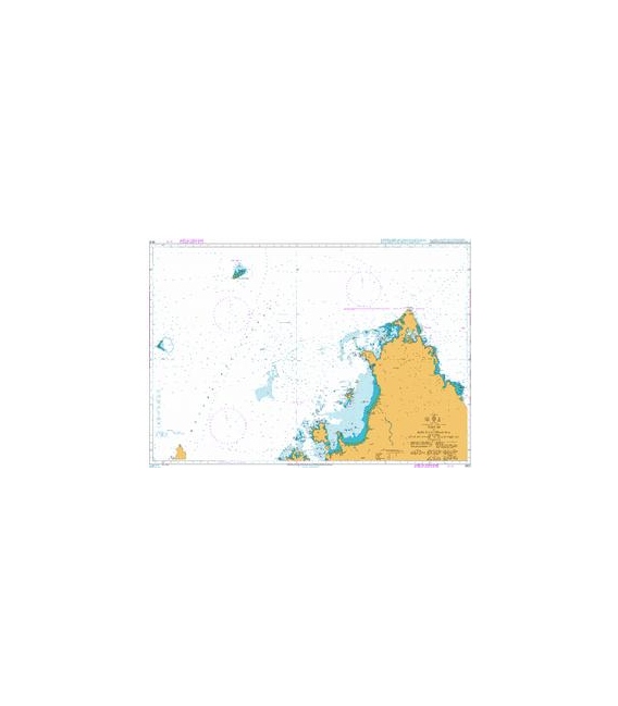
British Admiralty Nautical Chart 3876 Nosy Be to Baie d’Antsiranana, including Recif du Geyser and Iles Glorieuses
₱3,500.00
BA3876
British Admiralty Nautical Chart 3876 Nosy Be to Baie d’Antsiranana, including Recif du Geyser and Iles Glorieuses
is corrected up to date. Admiralty standard nautical charts comply with Safety of Life at Sea (SOLAS) regulations and are ideal for professional, commercial and recreational use. Charts within the series consist of a range of scales, useful for passage planning, ocean crossings, coastal navigation and entering port. Mariners should always use the largest scale nautical chart appropriate to their needs. In particularly busy seaways such as the English Channel, Gulf of Suez and the Malacca and Singapore Straits, the standard nautical charts are supplemented by mariners routeing guides which provide advice on route planning in these complex areas.
Chart 3876
Chart INT. 7720
Main Chart Details
- Chart Title: Nosy Be to Baie D’Antsiranana, including Recif du Geyser & Iles Gloriuses
- Publication Date: 25/07/2002
- Latest Edition date: 25/07/2002
- Chart Size: 1099 x 749 (mm)
Chart Panel Details
- Panel Name Nosy Be to Baie D’Antsiranana, including Recif du Geyser & Iles Gloriuses
- Natural Scale 350000
- North Limit 11 15′.00S
- East Limit 49 55′.00E
- South Limit 13 37′.00S
- West Limit 46 23′.00E
Be the first to review “British Admiralty Nautical Chart 3876 Nosy Be to Baie d’Antsiranana, including Recif du Geyser and Iles Glorieuses”
Related products

British Admiralty Charts
British Admiralty Nautical Chart 5: `Abd Al Kuri to Suqutra (Socotra)

British Admiralty Charts
British Admiralty Nautical Chart 26: England – South Coast, Harbours on the South Coast of Devon

British Admiralty Charts
British Admiralty Nautical Chart 31: Harbours on the South Coast of Cornwall
British Admiralty Charts
British Admiralty Nautical Chart 18: Falmouth Inner Harbour Including Penryn

British Admiralty Charts
British Admiralty Nautical Chart 20: France – West Coast, Île d’Ouessant to Pointe de la Coubre
Reviews
There are no reviews yet.