
British Admiralty Nautical Chart 3746 Loch Long and Loch Goil
₱3,000.00
BA3746
British Admiralty Nautical Chart 3746 Loch Long and Loch Goil
is corrected up to date. Admiralty standard nautical charts comply with Safety of Life at Sea (SOLAS) regulations and are ideal for professional, commercial and recreational use. Charts within the series consist of a range of scales, useful for passage planning, ocean crossings, coastal navigation and entering port. Mariners should always use the largest scale nautical chart appropriate to their needs. In particularly busy seaways such as the English Channel, Gulf of Suez and the Malacca and Singapore Straits, the standard nautical charts are supplemented by mariners routeing guides which provide advice on route planning in these complex areas.
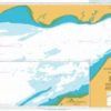
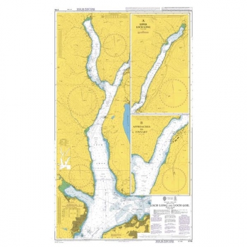
Chart 3746
Chart INT. 1635
Main Chart Details
- Chart Title: Loch Long and Loch Goil
- Publication Date: 31/10/1975
- Latest Edition date: 21/11/2019
- Chart Size: 630 x 1060 (mm)
Chart Panel Details
- Panel Name Loch Long and Loch Goil
- Area Name Scotland – West Coast, Firth of Clyde
- Natural Scale 25000
- North Limit 56 10′.58N
- East Limit 4 42′.85W
- South Limit 55 56′.29N
- West Limit 4 57′.98W
- Panel Name A Upper Loch Long
- Area Name Scotland – West Coast, Firth of Clyde
- Natural Scale 25000
- North Limit 56 13′.00N
- East Limit 4 44′.30W
- South Limit 56 06′.77N
- West Limit 4 50′.78W
- Panel Name B Approaches to Finnart
- Area Name Scotland – West Coast, Firth of Clyde
- Natural Scale 12500
- North Limit 56 07′.50N
- East Limit 4 49′.43W
- South Limit 56 04′.99N
- West Limit 4 52′.68W
Be the first to review “British Admiralty Nautical Chart 3746 Loch Long and Loch Goil”
Related products

British Admiralty Charts
British Admiralty Nautical Chart 26: England – South Coast, Harbours on the South Coast of Devon


British Admiralty Charts
British Admiralty Nautical Chart 28: England – South Coast, Salcombe Harbour. Salcombe
British Admiralty Charts
British Admiralty Nautical Chart 34: England – West Coast, Isles of Scilly
British Admiralty Charts
British Admiralty Nautical Chart 7: Gulf of Aden, Yemen, Aden Harbour and Approaches

British Admiralty Charts
British Admiralty Nautical Chart 12: Al `Aqabah to Duba and Ports on the Coast of Saudi Arabia

Reviews
There are no reviews yet.