
British Admiralty Nautical Chart 3497 River Humber Immingham to Humber Bridge
₱3,500.00
BA3497
British Admiralty Nautical Chart 3497 River Humber Immingham to Humber Bridge
is corrected up to date. Admiralty standard nautical charts comply with Safety of Life at Sea (SOLAS) regulations and are ideal for professional, commercial and recreational use. Charts within the series consist of a range of scales, useful for passage planning, ocean crossings, coastal navigation and entering port. Mariners should always use the largest scale nautical chart appropriate to their needs. In particularly busy seaways such as the English Channel, Gulf of Suez and the Malacca and Singapore Straits, the standard nautical charts are supplemented by mariners routeing guides which provide advice on route planning in these complex areas.
Chart 3497
Chart INT. 1554
Main Chart Details
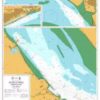
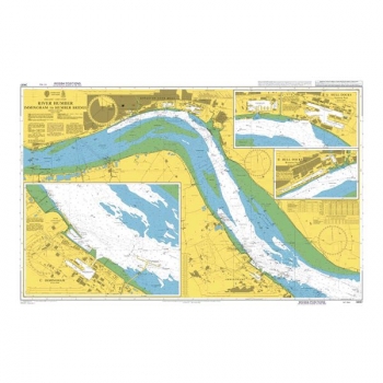
- Chart Title:River Humber, Immingham to Humber Bridge and the Rivers Ouse and Trent
- Publication Date:05/04/1974
- Latest Edition date: 16/05/2019
- Chart Size:1020 x 631 (mm)
Chart Panel Details
- Panel NameRiver Humber, Immingham to Humber Bridge and the Rivers Ouse and Trent
- Area NameEngland – East Coast
- Natural Scale 25000
- North Limit53 45′.32N
- East Limit0 04′.53W
- South Limit53 36′.81N
- West Limit0 27′.66W
- Panel NameA Humber Bridge to Whitton Ness
- Area NameEngland – East Coast
- Natural Scale 50000
- North Limit53 44′.20N
- East Limit0 26′.70W
- South Limit53 40′.36N
- West Limit0 37′.15W
- Panel NameB Whitton Ness to Goole and Keadby
- Area NameEngland – East Coast
- Natural Scale 50000
- North Limit53 44′.05N
- East Limit0 35′.80W
- South Limit53 35′.01N
- West Limit0 52′.30W
- Panel NameC Keadby to Gainsborough
- Area NameEngland – East Coast
- Natural Scale 100000
- North Limit53 35′.17N
- East Limit0 40′.09W
- South Limit53 24′.16N
- West Limit0 50′.05W
- Panel NameD Goole
- Area NameEngland – East Coast
- Natural Scale 5000
- North Limit53 42′.23N
- East Limit0 51′.72W
- South Limit53 41′.72N
- West Limit0 52′.91W
Be the first to review “British Admiralty Nautical Chart 3497 River Humber Immingham to Humber Bridge”
Related products

British Admiralty Charts
British Admiralty Nautical Chart 34: England – West Coast, Isles of Scilly
British Admiralty Charts
British Admiralty Nautical Chart 20: France – West Coast, Île d’Ouessant to Pointe de la Coubre

British Admiralty Charts
British Admiralty Nautical Chart 31: Harbours on the South Coast of Cornwall

Reviews
There are no reviews yet.