British Admiralty Nautical Chart 2618 Harbours in Taiwan
₱3,500.00
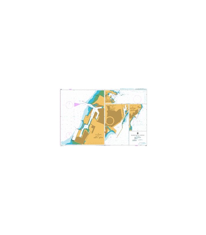
BA2618
British Admiralty Nautical Chart 2618 Harbours in Taiwan
is corrected up to date. Admiralty standard nautical charts comply with Safety of Life at Sea (SOLAS) regulations and are ideal for professional, commercial and recreational use. Charts within the series consist of a range of scales, useful for passage planning, ocean crossings, coastal navigation and entering port. Mariners should always use the largest scale nautical chart appropriate to their needs. In particularly busy seaways such as the English Channel, Gulf of Suez and the Malacca and Singapore Straits, the standard nautical charts are supplemented by mariners routeing guides which provide advice on route planning in these complex areas.
Chart 2618
Main Chart Details
- Chart Title: Harbours in Taiwan
- Publication Date: 25/11/1988
- Latest Edition date: 24/10/2019
- Chart Size: 1020 x 650 (mm)
Chart Panel Details
- Panel Name A – T’ai-chung
- Natural Scale 20000
- North Limit 24 19′.40N
- East Limit 120 32′.29E
- South Limit 24 12′.35N
- West Limit 120 26′.18E
- Panel Name C – Approaches to Hua – Lien
- Natural Scale 30000
- North Limit 24 01′.05N
- East Limit 121 39′.79E
- South Limit 23 55′.89N
- West Limit 121 36′.23E
- Panel Name D – Hua-Lien
- Natural Scale 10000
- North Limit 24 00′.34N
- East Limit 121 38′.49E
- South Limit 23 57′.71N
- West Limit 121 36′.83E
- Panel Name B – Su-Ao
- Natural Scale 25000
- North Limit 24 36′.65N
- East Limit 121 58′.29E
- South Limit 24 34′.54N
- West Limit 121 50′.99E
Be the first to review “British Admiralty Nautical Chart 2618 Harbours in Taiwan”
Related products

British Admiralty Charts
British Admiralty Nautical Chart 12: Al `Aqabah to Duba and Ports on the Coast of Saudi Arabia

British Admiralty Charts
British Admiralty Nautical Chart 15: Red Sea, Saudi Arabia and Yemen, Approaches to Jizan

British Admiralty Charts
British Admiralty Nautical Chart 29: Brazil – South Coast, Porto de Santos


British Admiralty Charts
British Admiralty Nautical Chart 26: England – South Coast, Harbours on the South Coast of Devon
Reviews
There are no reviews yet.