
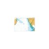
British Admiralty Nautical Chart 1321 Ports and Terminals in the Gulf of Guinea
₱3,000.00
British Admiralty Nautical Chart 1321 Ports and Terminals in the Gulf of Guinea
is corrected up to date. Admiralty standard nautical charts comply with Safety of Life at Sea (SOLAS) regulations and are ideal for professional, commercial and recreational use. Charts within the series consist of a range of scales, useful for passage planning, ocean crossings, coastal navigation and entering port. Mariners should always use the largest scale nautical chart appropriate to their needs. In particularly busy seaways such as the English Channel, Gulf of Suez and the Malacca and Singapore Straits, the standard nautical charts are supplemented by mariners routeing guides which provide advice on route planning in these complex areas.
Chart 1321
Main Chart Details
- Chart Title:Ports and Terminals in the Gulf of Guinea
- Publication Date:29/09/1995
- Latest Edition date:29/03/2018
- Chart Size:650 x 1000 (mm)
Chart Panel Details
- Panel NameA Nun River Entrance
- Area NameNigeria
- Natural Scale50000
- North Limit4 20′.81N
- East Limit6 09′.69E
- South Limit4 11′.00N
- West Limit6 00′.75E
- Panel NameB Brass River Entrance
- Area NameNigeria
- Natural Scale50000
- North Limit4 20′.81N
- East Limit6 18′.30E
- South Limit4 13′.00N
- West Limit6 10′.00E
- Panel NameC Opobo River Entrance
- Area NameNigeria
- Natural Scale50000
- North Limit4 35′.61N
- East Limit7 38′.58E
- South Limit4 23′.00N
- West Limit7 29′.40E
- Panel NameD Bahia de Luba
- Area NameEquatorial Guinea, Isla de Bioko
- Natural Scale50000
- North Limit3 34′.04N
- East Limit8 35′.51E
- South Limit3 26′.50N
- West Limit8 31′.20E
- Panel NameE Punta Europa to Puerto de Malabo
- Area NameEquatorial Guinea , Isla de Bioko
- Natural Scale30000
- North Limit3 49′.52N
- East Limit8 47′.50E
- South Limit3 45′.00N
- West Limit8 39′.75E
- Panel NameF Puerto de Malabo
- Area NameEquatorial Guinea – Isla de Bioko
- Natural Scale12500
- North Limit3 46′.44N
- East Limit8 47′.29E
- South Limit3 45′.25N
- West Limit8 46′.00E
Be the first to review “British Admiralty Nautical Chart 1321 Ports and Terminals in the Gulf of Guinea”
Related products

British Admiralty Charts
British Admiralty Nautical Chart 26: England – South Coast, Harbours on the South Coast of Devon

British Admiralty Charts
British Admiralty Nautical Chart 12: Al `Aqabah to Duba and Ports on the Coast of Saudi Arabia

British Admiralty Charts
British Admiralty Nautical Chart 11: Jazireh-ye Khark and Approaches
British Admiralty Charts
British Admiralty Nautical Chart 17: Plans of the Santa Cruz and Adjacent Islands
British Admiralty Charts
British Admiralty Nautical Chart 30: Plymouth Sound and Approaches
British Admiralty Charts
British Admiralty Nautical Chart 32: England – South Coast, Falmouth to Truro
British Admiralty Charts
British Admiralty Nautical Chart 20: France – West Coast, Île d’Ouessant to Pointe de la Coubre
Reviews
There are no reviews yet.