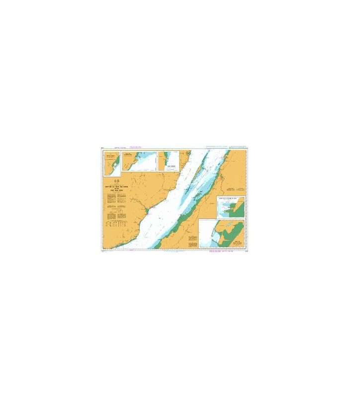
British Admiralty Nautical Chart 4782 Ile du bic au/to Cap de la Tete au Chien
₱3,500.00
Description
British Admiralty Nautical Chart 4782 Ile du bic au/to Cap de la Tete au Chien
is corrected up to date. Admiralty standard nautical charts comply with Safety of Life at Sea (SOLAS) regulations and are ideal for professional, commercial and recreational use. Charts within the series consist of a range of scales, useful for passage planning, ocean crossings, coastal navigation and entering port. Mariners should always use the largest scale nautical chart appropriate to their needs. In particularly busy seaways such as the English Channel, Gulf of Suez and the Malacca and Singapore Straits, the standard nautical charts are supplemented by mariners routeing guides which provide advice on route planning in these complex areas.
Chart 4782
Main Chart Details
- Chart Title: Ile du bic au/to Cap de la Tete au Chien
- Publication Date: 17/05/2012
- Latest Edition date: 11/08/2016
- Chart Size: 1088 x 748 (mm)
Chart Panel Details
- Panel Name Ile du bic au/to Cap de la Tete au Chien
- Natural Scale 80000
- North Limit 48° 26′.20N
- East Limit 68° 39′.00W
- South Limit 47° 54′.00N
- West Limit 69° 49′.00W
- Panel Name Les Escoumins
- Natural Scale 20000
- North Limit 48° 21′.30N
- East Limit 69° 22′.47W
- South Limit 48° 18′.50N
- West Limit 69° 25′.47W
- Panel Name Port de Gros-Cacouna
- Natural Scale 10000
- North Limit 47° 57′.30N
- East Limit 69° 29′.27W
- South Limit 47° 55′.40N
- West Limit 69° 32′.00W


Reviews
There are no reviews yet.